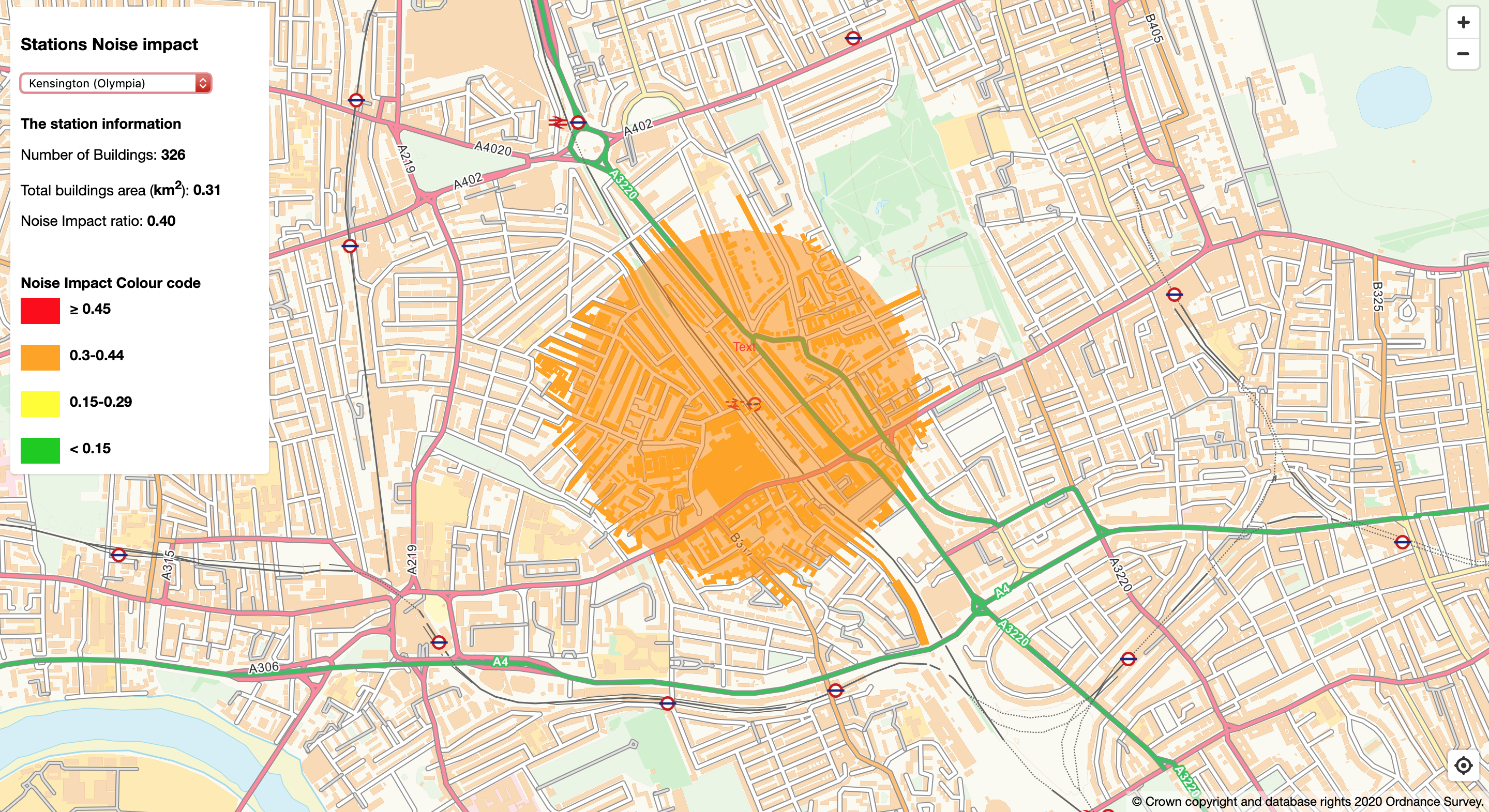
Stations Noise Impact
This web application aims to measure the noise impact to buildings near any random railway station in the UK and Ireland within a 500m radius. This application is using the content of the OS Vector Tile API in the "Road" style to generate the map, as well as the OS Features API product OS Zoomstack Layer, with the feature typenames listed below:
- Zoomstack_Railway_Stations
- Zoomstack_District_Buildings
You simply select a station from the dropdown menu and it generates the following information related to the station
- The total number of buildings within the radius
- Their total area
- The noise impact obtained by the ratio of buildings area to that of the radius
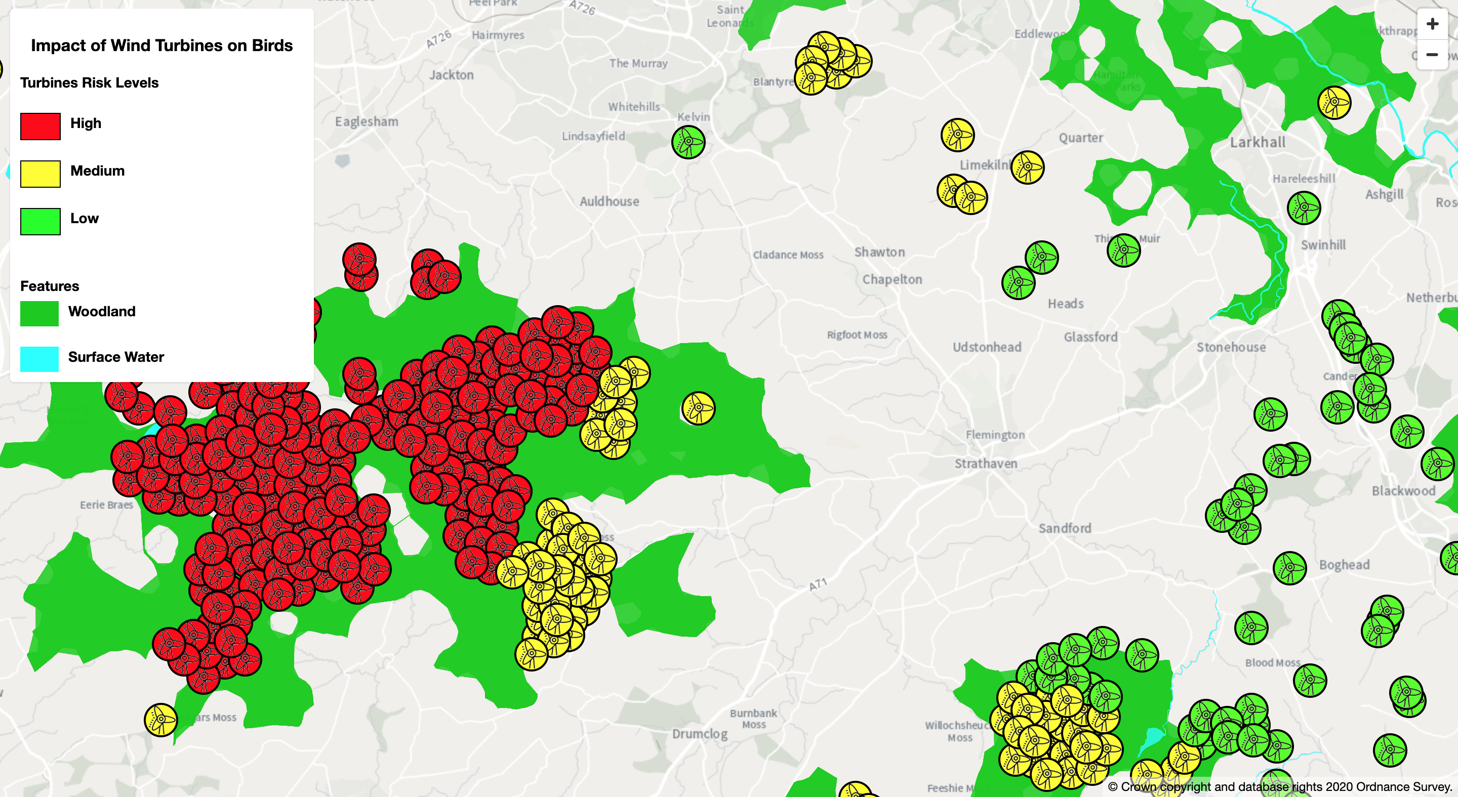
Impact of Wind Turbines on Birds
Check the risk levels wind turbines have on birds. The risk level turbines have on woodland and surface water birds is calculated by finding the areas of each feature within a 5 mile radius of a turbine, then combined to give an overall risk score. The features used in this project are:
- Topography_TopographicArea
- Zoomstack_Woodland
- Zoomstack_Surfacewater
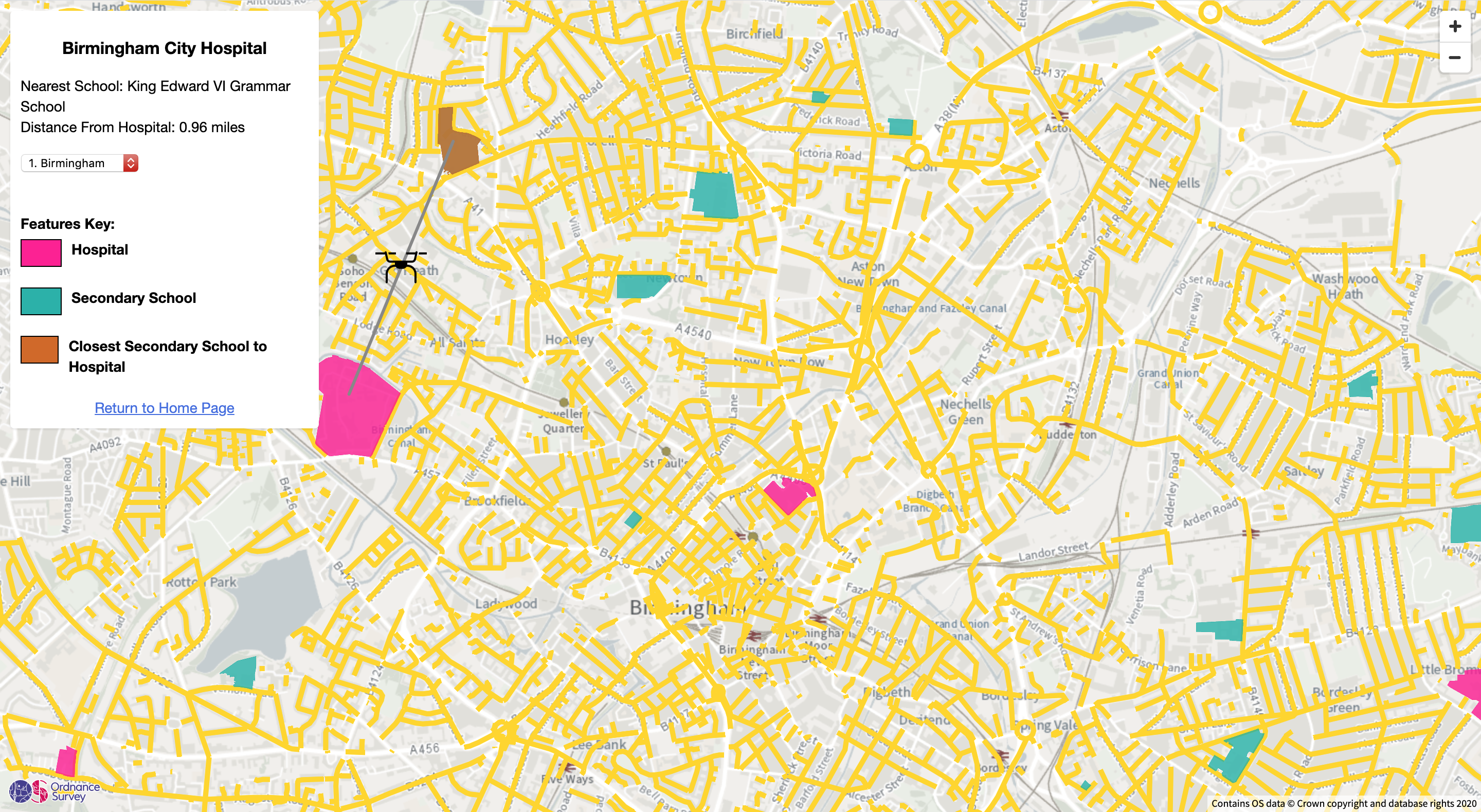
Finding the Nearest Secondary Schools to Hospitals
This project was created in light of the coronavirus pandemic. A scenario was created to address
a potential problem that could arise from the coronavirus, and OS Features from the DataHub API were used to
create a hypothetical solution.
At the moment, hospitals are incredibly stretched and find it difficult to cope
with the sheer number of coronavirus patients. In addition, schools are currently closed for the next few
months.
Another potential issue that arose was the number of patients contracting the coronavirus whilst in hospital
for
a non-coronavirus related issue. One possible solution to address these issues is to use schools as temporary
'coronavirus' hospitals or quarantine centres. Patients can stay and be treated in the schools, thus, reducing
the risk of spreading the disease. Quarantine centres have been used in countries around the world, with a
great
degree of success.
For this project, I identified the top 10 UTL areas with the most coronavirus cases as of 8th April
2020, using
the gov.uk
website
I matched these areas with the Highways_Street Feature, and used the Sites_FunctionalSite feature to add
hospitals
and Secondary Schools to the map. When you click on a hospital, it will show the nearest Secondary School to
it, and
this distance in miles it is from the hospital. The features I used in this project are:
- Sites_FunctionalSite
- Highways_Street
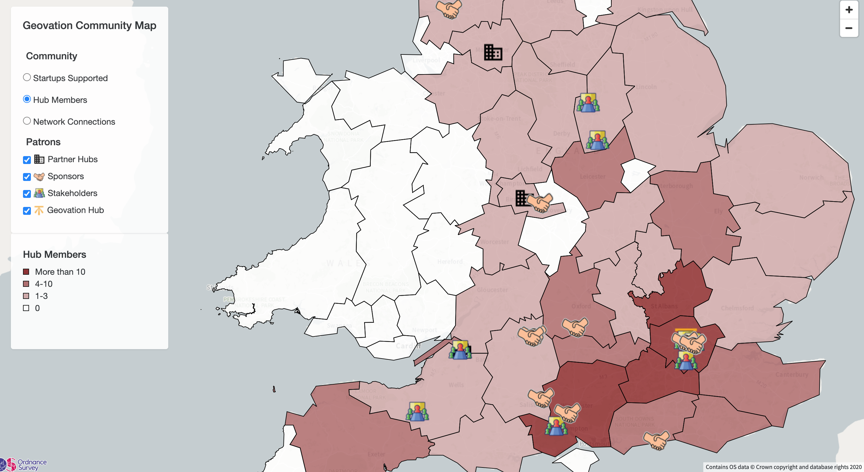
Geovation Community Map
The Geovation Community Map was made to get a better insight into the numbers of different personnel, and their locations. Markers are used to show the locations of partner hubs, sponsors and stakeholders, and I created choropleth maps to show where the startups supported, hub members and network connections are. For this project, I used:
- OS Vector Tile API
- OS Boundary Line Product
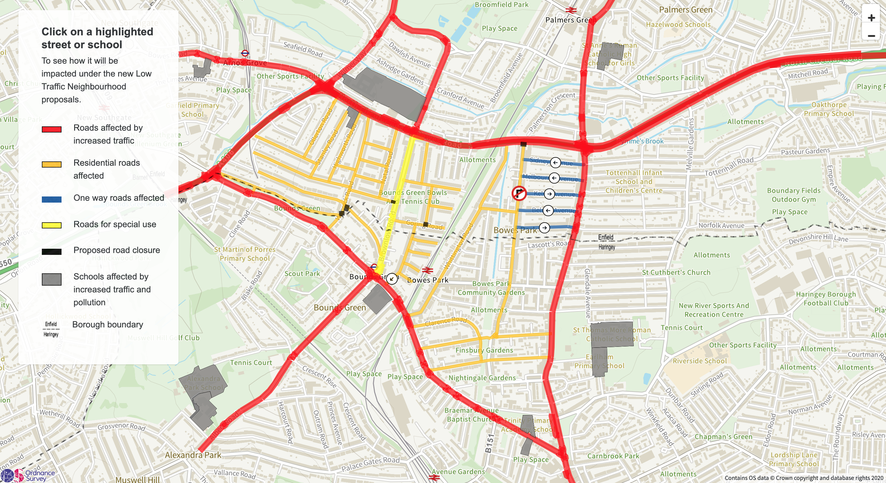
Assessing the Impact of the Bounds Green/Bowes LTN Scheme
In August 2020, Enfield Council decided to implement a Low Traffic Neighbourhood scheme at Bounds Green/Bowes.
However, many residents expressed their concerns with the proposals. I use this project to analyse residents' concerns,
whilst using OS Products and Features
from the OS Datahub APIs.
Click on a road, to see the concerns of residents as a result of the scheme, or click on a school to see the
average distance from the school to the main road,
as well as the number of students exposed to traffic and pollution from the main roads.
For this project, I used:
- OS Vector Tile API
- OS Boundary Line Product
- Sites_FunctionalSite
- Highways_Roadlink